

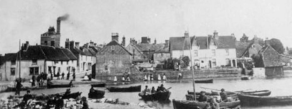
Description of Emsworth from Kelly's Directory 1875
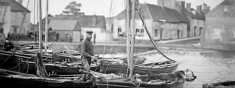
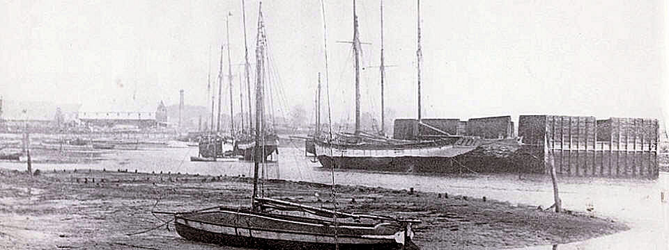
Emsworth - Ships and Shipping
Hayling Island Wadeway
Emsworth - Maritime Archaeology
An Archaeological Study of Oyster Beds at Emsworth
Slipper Mill
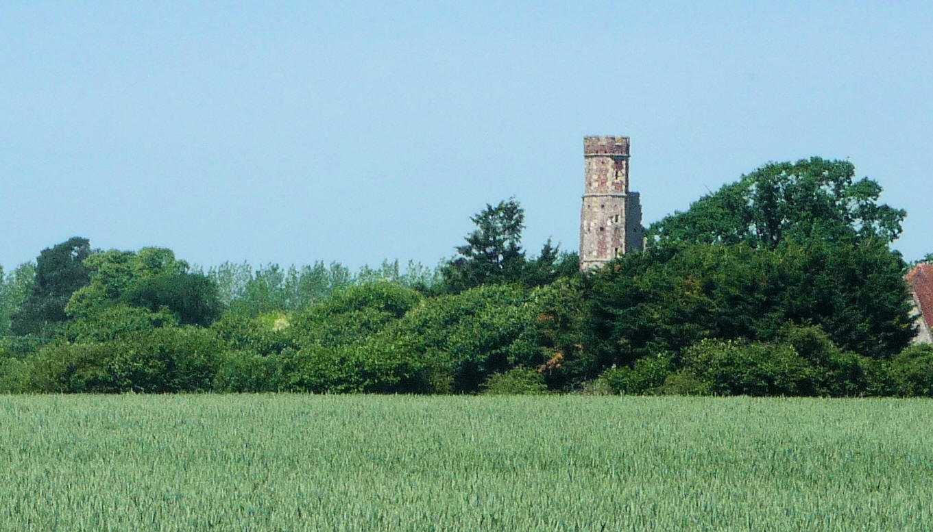
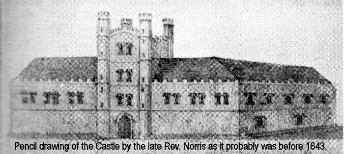
Warblington Castle
A Description of Emsworth from Kelly's Directory 1875
EMSWORTH
is a small town, and station on the London, Brighton and
South Coast railway, in the hundred of Bosmere, Havant
union, Portsmouth county court district, diocese and.
archdeaconry of Winchester, Havant rural deanery, 861 miles
from London, and 2 east from Havant, on the old road to
Chichester, on the Sussex border of the county, at the head
of an inlet of the sea called Emsworth channel, and opposite
to Thorney.
The manufacture of sailcloth, sacking, rope, twine„ and fishing nets is carried on, and there are a ship yard and two breweries. This place is a member of the ports of Portsmouth and Chichester, and carries on a trade in the importation of coal and exportation of timber and flour There are several vessels employed in the coasting trade and a considerable number of boats in the oyster fishery for which this town has long been celebrated. The oyster trade is likely to assume an important bearing upon the place owing to the establishment of beds in the Deeps; these beds are supplied partly by the native fish of Emsworth, and partly by the importation of oysters caught in the English Channel.
Fairs, for toys and pedlery, are
held on Easter Monday and Tuesday, and the 18th of July.
The proprietary chapel of St. Peter
is now disused. This place was formed in 1841 into an
ecclesiastical district out of Warblington parish. The
church of St. James was greeted in 1840, at an expense of
11,5200 it is a neat structure, in the Norman style, built
of flint, with stone dressings, and consists of chancel,
nave and aisles, with two rectangular turrets, terminating
in low spires, at the north. west and south west corners.
The register dates from 1841. The living is a rectory, with
residence, in the patronage of the rector of Warbling ton,
who has endowed it with its own rectorial tithes, amounting
to £180 per annum; and held by the Rev. Henry Winter
Sheppard, M.A., of Trinity College, Cambridge.
There are National and Infant
schools, supported by voluntary contributions ; also places
of worship for Baptists and Independents. He is a reading
room, supported by subscription.
The principal landowners are the
trustees of John Fenwick. The area is 610 acres; gross
estimated rental and rateable value included in Warblington;
and the population in 1871 was 1,824.
Parish Clerk, John Chitty
The first reference to a shipyard in Emsworth was during 1700 when John Smith was known to own a yard with two vessels on the stocks. He was wealthy, with house, yard, goods and money totalling £480 out of which material for his yard contributed £160. John Smith the younger was still running the yard in 1738.
There was also a yard at Langstone owned by another Smith in
1738, Mr Robert Smith.
-
A shipbuilding yard is also marked near Hendy’s Quay in Emsworth. It is located within a cluster of
 associated industries including timber yards, a saw mill
and a smithy. The oyster carrier Terror restored by Dolphin Quay Boatyard in
Emsworth, was thought built in Emsworth originally
during the second half of the 19th century. In 1817, the
biggest fishing ports in the harbour were Emsworth (30
boats), Bosham (25) and West Wittering (10); all other
places had not more than a handful each. Some boats
fished just in the Chichester Harbour, but bigger ones
went out to sea. J D Foster of Emsworth built up an
oyster dredging fleet of some ten vessels
in the late 19th century, but his oyster beds
became polluted by the local sewage works and in 1902
some Emsworth oysters eaten at a banquet in Winchester
led to sickness and death, followed by the closure of
the local oyster fishery. It was revived again after
WW1, but it was ended by WW2.
associated industries including timber yards, a saw mill
and a smithy. The oyster carrier Terror restored by Dolphin Quay Boatyard in
Emsworth, was thought built in Emsworth originally
during the second half of the 19th century. In 1817, the
biggest fishing ports in the harbour were Emsworth (30
boats), Bosham (25) and West Wittering (10); all other
places had not more than a handful each. Some boats
fished just in the Chichester Harbour, but bigger ones
went out to sea. J D Foster of Emsworth built up an
oyster dredging fleet of some ten vessels
in the late 19th century, but his oyster beds
became polluted by the local sewage works and in 1902
some Emsworth oysters eaten at a banquet in Winchester
led to sickness and death, followed by the closure of
the local oyster fishery. It was revived again after
WW1, but it was ended by WW2.

Making & export of malt becomes important at Chi and Havant:
malt became increasingly important after mid C17 when retail
productions of beer & ale began to supplant domestic
production. Easy for clothiers to change to being maltsters.
As well as Chichester and Havant, smaller scale maltsters
existed at Emsworth and Bosham. From17th century on, coastal
trade was more important to Chichester Harbourthan foreign
trade.
Maritime History of Chichester
Harbour
Manhood Peninsula
Partnership
http://peninsulapartnership.org.uk/
This causeway runs from the village of Langstone southwards
to Hayling Island and is severed by two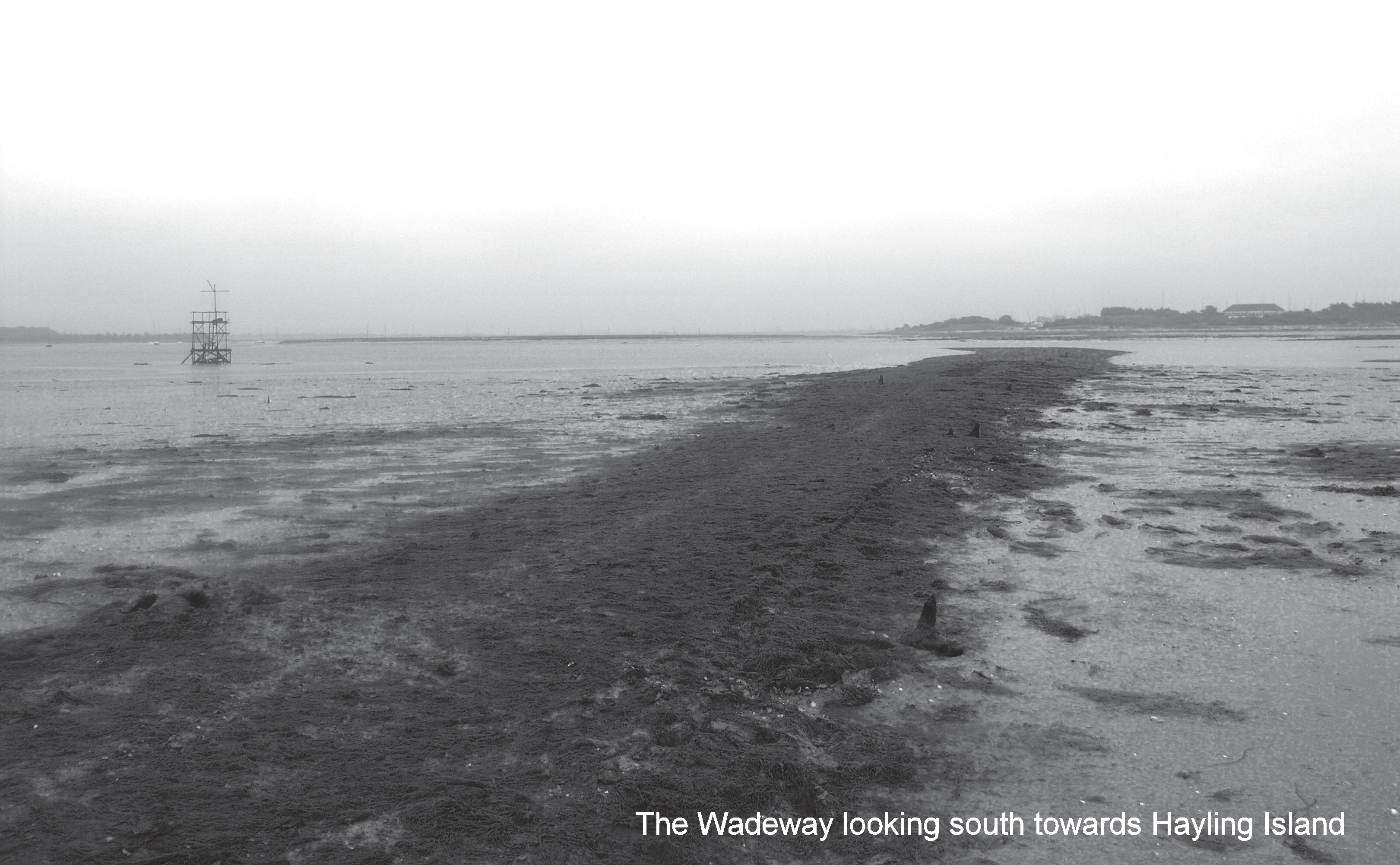 channels at all but the lowest of tides. It was long
thought likely to date from at least as early as the Bronze
Age, when there was significant activity in the area and the
Wadeway would have been the only land crossing to Hayling
Island until permission was granted to build a bridge in
1817. In 1821 it was cut through by the Portsmouth to
Arundel canal.
channels at all but the lowest of tides. It was long
thought likely to date from at least as early as the Bronze
Age, when there was significant activity in the area and the
Wadeway would have been the only land crossing to Hayling
Island until permission was granted to build a bridge in
1817. In 1821 it was cut through by the Portsmouth to
Arundel canal.
The first documentary reference to the Wadeway dates to 1552
and the toll for crossing the feature. Later references
mention the costs of maintenance. The first cartographic
evidence of the Wadeway is found on Taylor’s 1759 map.
A topographical survey and recording of features on the
Wadeway was carried out in 2000 in conjunction with local
volunteers. Ten timber structures were recorded, which
appeared to provide structural support for the causeway.
A more detailed survey in 2008 included excavation work and
auger surveys to analyse the composition of the structure
and seek artefacts to help in dating the structure. No
significant artefacts were discovered, however a combination
of radio-carbon dating, palaeoenvironmental analysis and
other techniques indicated that the area was terrestrial in
nature until at least the Post Roman period, and the
causeway is most likely to have been constructed in the 13th
or 14th century AD.
| THE WADEWAY: INVESTIGATION OF THE MEDIEVAL
CROSSING POINT FROM LANGSTONE VILLAGE TO HAYLING
ISLAND By Julie Satchell with contributions by Paul Donohue, Rob Scaife and Simon Bray |
Emsworth - Maritime Archaeology
The Maritime Archaeology Trust (MATM joined forces with
the Emsworth Maritime and Historical Trust (EMHT) and
Chichester and District Archaeology Society (CDAS) to help
lead volunteers who spent a soggy and cold January and
February in 2008 surveying abandoned oyster beds on the
Emsworth foreshore. Volunteers spent long hours on the
foreshore racing to record the remains of the beds ahead of
the rising tide.
The project, funded by a grant from
the Chichester Harbour Conservancy Sustainable Development
Fund recorded the remains of several timber-lined pitson the
foreshore. These were dug to store oysters for a huge oyster
industry that thrived in Emsworth in the 19th and early 20th
centuries. The industry collapsed in 1902 after oysters
contaminated by typhoid from a new sewer in Emsworth Harbour
were served at banquets at Winchester and Southampton. The
oysters poisoned several people and killed the Dean of
Winchester.
Volunteers were given a day of foreshore fieldwork and
survey training by the MAT and a guidance manual was created
to assist them in the archaeological survey of the beds. The
team recorded numerous beds, the positions of which were
recorded with sufficient accuracy to identify the original
pond owners from historic maps. The project culminated in a
special display on the oyster industry at the Emsworth
Museum that
incorporated volunteers plans and records of the site.
The Maritime Archaeology Trust
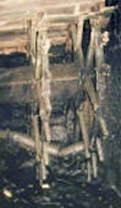
 One
of the largest structures surveyed was a large post-medieval wharf
at Warblington that consisted of
three possibly associated features. The wharf was built of
square timber piles, some with bracing timbers and iron
bolts, a compacted surface – probably a slipway – and the
timber posts of a coastal defence revetment.
One
of the largest structures surveyed was a large post-medieval wharf
at Warblington that consisted of
three possibly associated features. The wharf was built of
square timber piles, some with bracing timbers and iron
bolts, a compacted surface – probably a slipway – and the
timber posts of a coastal defence revetment.
UNCOVERING THE PAST
Archaeological discoveries in Chichester Harbour AONB
2004–2007
Uncovering the Past An Archaeological Study of Oyster Beds
at Emsworth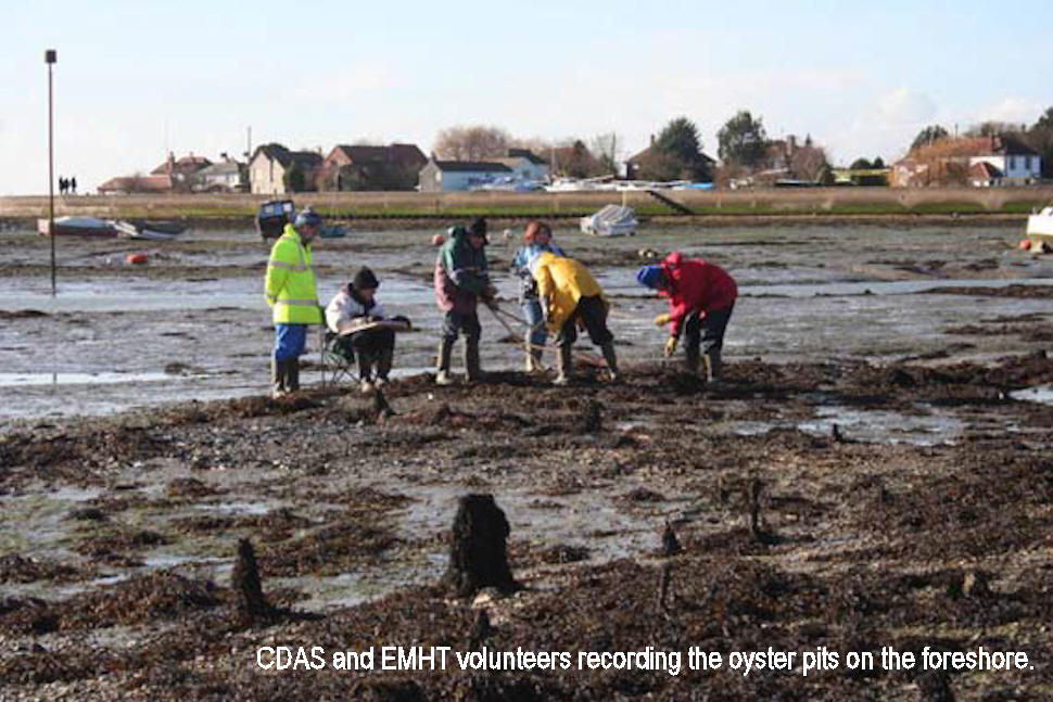
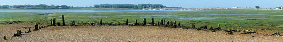
The Emsworth oyster beds were part of a system of natural
and artificial beds and pits used to seed, sort and grow
oysters. The industry included fleet of dredging vessels to
collect oysters from natural and artificial beds as well as
from sources abroad. The timber remains of the oyster beds
are visible on the foreshore at low tide. Archaeological
investigation of these remains was undertaken in 2008. Work
included foreshore survey involving local volunteers and
historical research to help understand the development of
the site.
Read more: Project Summary Julie Satchell 2008
Slipper Mill
In the mid 1700s the dockyard in Portsmouth was growing
rapidly to counter the threat from the French, and the
demand for flour to support both the naval and civil
population increased dramatically. Sites for watermills
besides the streams had all been developed so the
entrepreneurs turned to tidal locations. Slipper Mill was
amongst the local mills built in this period.
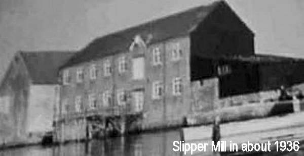 Slipper
Mill was built by Thomas Hendy in the 1760's as part of his
development at the mouth of the River Ems. The mill itself
was built close to the bank over the water, with a large
flanking store on the site of the present "Slipper Mill"
building. The mill was rebuilt on several occasions
following fires caused by the very dusty atmosphere,
with overheating bearings being the probable cause.
Slipper
Mill was built by Thomas Hendy in the 1760's as part of his
development at the mouth of the River Ems. The mill itself
was built close to the bank over the water, with a large
flanking store on the site of the present "Slipper Mill"
building. The mill was rebuilt on several occasions
following fires caused by the very dusty atmosphere,
with overheating bearings being the probable cause.
In 1912 a great storm swept the mill house away and the
miller and his family were relocated in the Roundhouse until
Slipper Mill Cottage was built (by Quinnells (IoW) Ltd).
The mill was sold with a restrictive covenant in 1936, and
finally ceased working in 1939. It was
later demolished as was the former store which was converted
into dwelling units for sale in 1970.
The undershot mill-wheel (see right) is still in position.
The tail race opening can be seen underneath the balconies
on the West side of the building.
Traces of the foundations of the mill wall flank the garage
wall on the North side of the complex.
In Roman times there may have
been an outpost here to guard the ford, but as there was no
quarry stone available on the spot, it would consist of only
a low substructure of bricks with a timbered upper part and
of only one storey. If there was a house in Saxon days it
would be wholly of timber beams in a district where wood was
so plentiful and stone so scarce.
Margaret of Salisbury is the
first person of whom we hear definitely as having an
important house at Warblington, and it was probably she who
built the great castle. She certainly dwelt there habitually
in her later years and we may picture her walking with her
household to the old Church and entering by that beautiful
timbered porch which even in her day was at least
150-years-old.
The castle was completed around 1520 and detailed building accounts for the years 1517/18 survive. A survey carried out in 1632 describes it as follows:
"The
Castle formed a quadrangle deeply moated round on every
side, with an entrance from the west, over a drawbridge and
beneath an arched gateway, flanked with turrets at each
corner, a porter's lodge to, the south, and an armoury to
the north. The south quadrangle comprised the Chapel, 42
feet by 32 (13 metres by 10), and the Great Hall, 58 feet by
32 (18 metres by 10), communicating at one end with a small
cellar and at the other with the buttery, kitchen, cellar
and brewery, and from hence were the dishes conveyed to the
buttery-hatch within the screen of the Hall. The state
apartments were at the northern quadrangle, and a gallery
and sleeping rooms above. The stone with which the building
was faced came from the Isle of Wight, but the mouldings and
ornamental parts were of the fine-grained stone of Caen in
Normandy."
"